
California Atmospheric River Storm Forecast A Detailed Look
California atmospheric river storm forecast is crucial for residents and authorities alike. This forecast delves into the intricacies of atmospheric rivers, examining their formation, historical patterns, and projected impacts. We’ll explore forecasting models, regional vulnerabilities, potential water resource effects, public safety measures, economic consequences, and future projections. Get ready to understand the challenges and potential solutions surrounding these powerful storms.
This comprehensive analysis will provide a deep dive into the science behind atmospheric rivers and their effects on California. We’ll cover various aspects, from the fundamental mechanics of these weather systems to the practical implications for communities and infrastructure.
Overview of Atmospheric River Storms in California
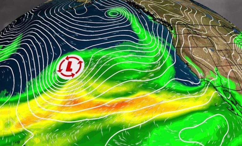
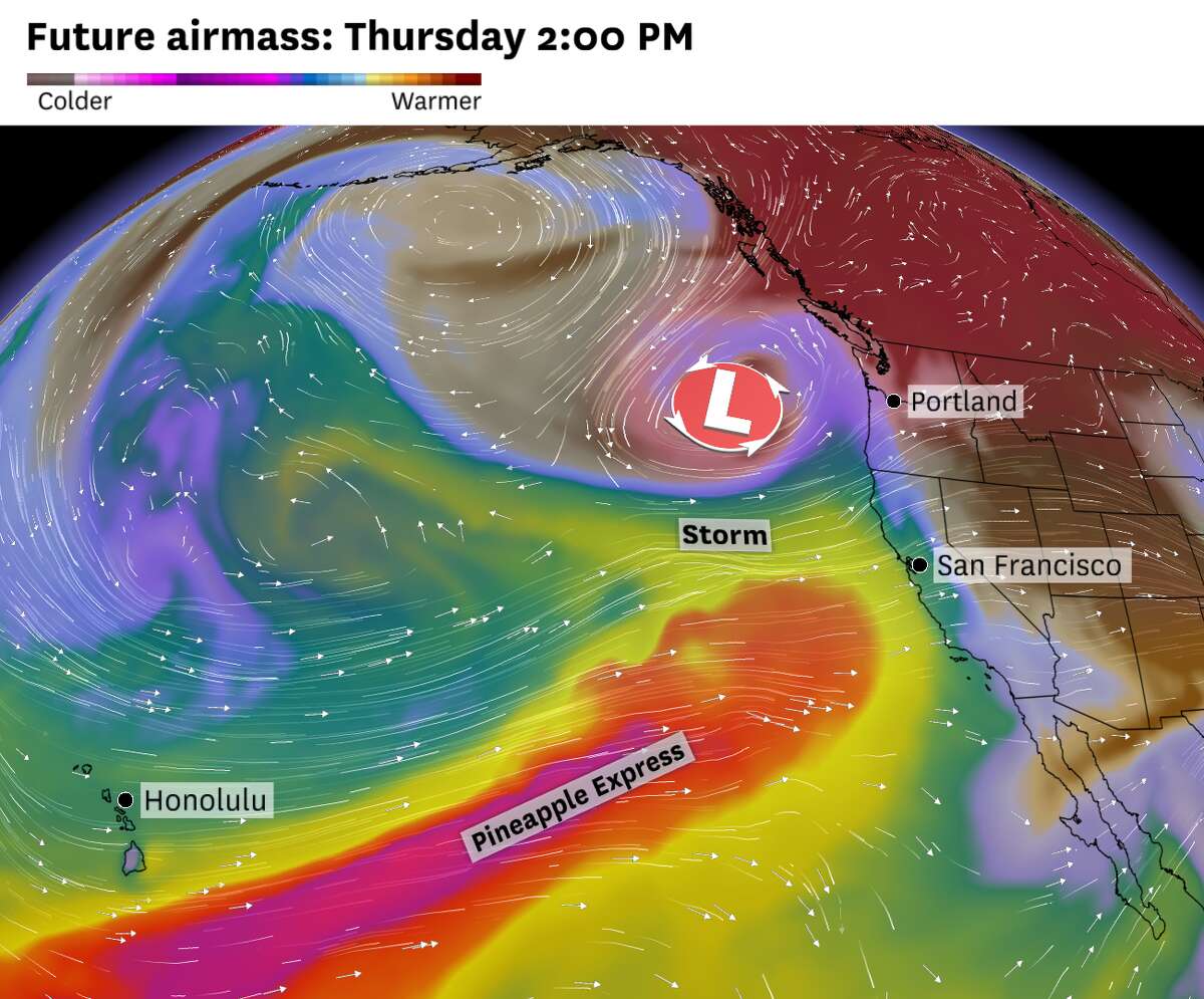
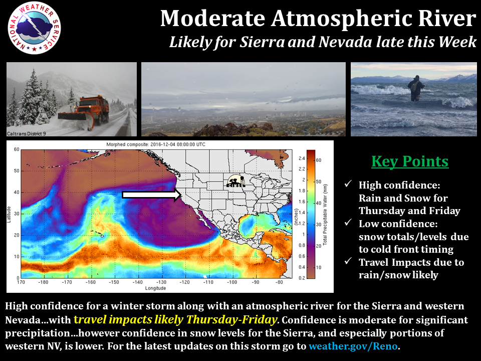
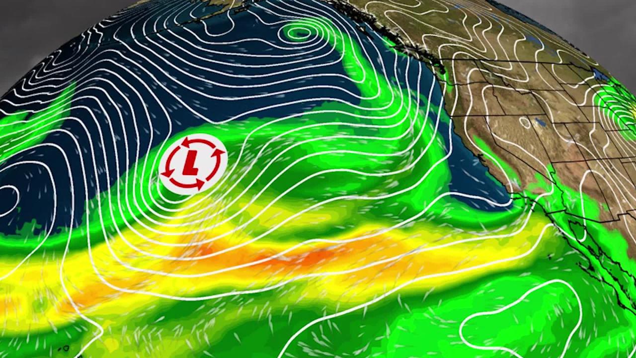
Atmospheric rivers (ARs) are a significant weather phenomenon impacting California’s diverse ecosystems and communities. These long, narrow corridors of concentrated moisture in the atmosphere bring substantial precipitation, often leading to flooding, landslides, and other hazards. Understanding their characteristics and historical patterns is crucial for effective preparedness and mitigation strategies.California’s geography, with its diverse topography and varied climates, makes it particularly vulnerable to the effects of atmospheric rivers.
These systems, originating from the tropics or subtropics, carry enormous amounts of water vapor, which can be deposited as rain or snow, dramatically altering the region’s hydrology.
Characteristics and Formation Processes of Atmospheric Rivers
Atmospheric rivers are essentially rivers in the sky. They are long, narrow regions of concentrated water vapor in the atmosphere, typically extending thousands of kilometers. Their formation often involves the convergence of winds and air masses, leading to the condensation and accumulation of moisture. The process is complex, influenced by factors such as the strength of the jet stream, sea surface temperatures, and the topography of the surrounding landmasses.
The intensity and duration of these atmospheric rivers directly correlate with the amount of precipitation they deliver.
Historical Context of AR-Related Storms in California
California has a long history of experiencing intense precipitation events linked to atmospheric rivers. These events have shaped the state’s landscapes, impacting water resources, agriculture, and infrastructure. Significant historical storms, like the 1997-98 El Niño event and the 2017 atmospheric river storm, serve as crucial case studies for understanding the potential impacts and developing mitigation strategies.
Comparison of Past Atmospheric River Events
The intensity and duration of past atmospheric river events vary significantly. Analyzing these differences is vital for comprehending the potential impacts and refining forecasting models. The following table summarizes some notable historical AR events, highlighting their relative intensity and duration:
| Event | Approximate Date | Intensity (estimated precipitation amount) | Duration (days) | Key Impacts |
|---|---|---|---|---|
| 1997-98 El Niño | Winter 1997-98 | Record-breaking rainfall across many regions | Several months | Significant flooding, landslides, and damage to infrastructure |
| 2017 Atmospheric River Storm | January 2017 | Heavy rainfall in a concentrated period | Several days | Severe flooding, damage to infrastructure, and disruption to transportation |
| 2023 Atmospheric River Storm (Example) | October 2023 | Significant rainfall across various areas | 3-4 days | Widespread flooding, mudslides, and impacts to local communities |
The table provides a simplified comparison. Factors like specific geographic location and the unique characteristics of each atmospheric river event should be considered for a complete analysis. Further research and analysis of historical data are needed to refine our understanding of the long-term patterns and variability of atmospheric river events in California.
Forecasting Methods and Models
California’s atmospheric rivers (ARs) pose a significant challenge to forecasting due to their complex nature and unpredictable behavior. Accurate predictions are crucial for mitigating potential damage and ensuring public safety. Various models and techniques are employed by different organizations to forecast these storms, each with its own strengths and weaknesses. Understanding these methods is essential for interpreting the information presented in weather forecasts and developing effective preparedness strategies.Different forecasting models utilize various approaches to predict the characteristics of AR storms, ranging from sophisticated numerical weather prediction (NWP) models to statistical analyses.
The accuracy and reliability of these models vary depending on the specific input data, the complexity of the model, and the particular characteristics of the AR system. These factors must be considered when evaluating the forecast information.
Numerical Weather Prediction Models, California atmospheric river storm forecast
Numerical weather prediction (NWP) models are the cornerstone of AR forecasting. These sophisticated computer programs solve the equations of fluid dynamics to simulate the evolution of the atmosphere. Different models vary in their resolution and complexity, affecting their accuracy and reliability. For instance, higher resolution models can capture finer details of the AR system, leading to more precise forecasts.
Statistical Models
Statistical models provide an alternative approach to forecasting AR storms. These models use historical data to identify patterns and relationships between various atmospheric variables and AR characteristics. While less computationally intensive than NWP models, statistical models can sometimes capture subtle relationships that are missed by NWP models. They often prove valuable in identifying the likelihood of an AR event occurring.
Comparison of Forecasting Techniques
Different organizations employ various forecasting techniques, leading to slight variations in the predictions. For example, some organizations may focus more heavily on NWP models, while others may incorporate statistical techniques to refine the forecasts. The choice of techniques often depends on the available computational resources, expertise, and the specific needs of the forecasting organization.
Input Variables for Different Models
The accuracy of the forecasts depends significantly on the quality and quantity of input data used in the models. Different models require different types of input data.
| Model Type | Key Input Variables |
|---|---|
| NWP Models | Surface observations (temperature, pressure, humidity), upper-air data (wind, temperature, moisture), satellite imagery, radar data, and numerical initial conditions. |
| Statistical Models | Historical data on AR characteristics, including precipitation amounts, locations, duration, and associated atmospheric conditions (e.g., sea surface temperatures, wind patterns). |
The table above Artikels some key input variables for different forecasting models. Accurate and timely data collection is crucial for the success of any forecasting effort. For example, timely and reliable satellite data are essential for monitoring the evolution of ARs and their impact on California’s weather patterns.
Impacts of Storms on Different Regions
Atmospheric rivers (ARs) wreak havoc across California, impacting various regions in unique ways. Understanding these regional differences is crucial for effective preparedness and mitigation strategies. The diverse topography and infrastructure of the state amplify the risks associated with these powerful storms. From coastal flooding to mountain mudslides, the effects ripple through the entire landscape.Different California regions experience varying intensities and types of impacts during atmospheric river storms.
The specific impacts depend on factors like the storm’s path, intensity, and the geographical characteristics of the region. This necessitates a nuanced approach to risk assessment and vulnerability analysis, tailored to the particular challenges of each area.
Coastal Impacts
Coastal regions are particularly vulnerable to high winds, heavy rainfall, and storm surges. Strong winds can cause coastal erosion, damaging seawalls and infrastructure. Heavy rainfall leads to significant runoff, increasing the risk of flooding in low-lying areas. Storm surges, combined with high tides, can inundate coastal communities, damaging homes, businesses, and critical infrastructure. The potential for flooding and erosion is significantly heightened in areas with a history of coastal erosion and poor drainage.
Mountain Impacts
Mountain ranges experience intense rainfall, leading to flash floods, mudslides, and debris flows. The steep slopes and concentrated runoff rapidly amplify the risk of these devastating events. The combination of heavy rainfall and saturated ground dramatically increases the likelihood of landslides. Infrastructure such as roads and bridges are especially vulnerable to damage, potentially isolating communities and hindering emergency response efforts.
Valley Impacts
Valleys, often characterized by agricultural lands and populated areas, are susceptible to widespread flooding and water damage. Prolonged heavy rainfall can saturate the ground, leading to overflowing rivers and streams, inundating homes and businesses. Agricultural lands may suffer significant crop damage, and livestock may be affected. The infrastructure in valleys, including roads, bridges, and water systems, can also be severely compromised by the floodwaters.
The risk is heightened in valleys with poor drainage systems and historical flood patterns.
Potential Infrastructure Damage
Atmospheric river storms can inflict significant damage on California’s infrastructure. Roads and bridges can be washed out, disrupting transportation and isolating communities. Power grids can be overloaded, leading to widespread power outages. Damage to water infrastructure, including dams and reservoirs, can compromise water supply and sanitation systems. The potential for damage to critical infrastructure is a serious concern during AR events.
Damage Scenarios by Geographic Area
| Geographic Area | Potential Damage Scenarios |
|---|---|
| Coastal Areas | Coastal erosion, seawall damage, flooding, infrastructure damage, disruption of transportation |
| Mountain Ranges | Flash floods, mudslides, debris flows, road closures, bridge damage, disruption of emergency response |
| Valleys | Widespread flooding, water damage to homes and businesses, crop damage, disruption of transportation and agricultural activities |
Potential Impacts on Water Resources
Atmospheric rivers (ARs) significantly impact California’s water resources, often bringing vital rainfall but also posing challenges for water management. Understanding these impacts is crucial for developing effective strategies to mitigate potential risks and maximize the benefits of these storms. The unpredictable nature of ARs makes forecasting and preparedness essential for minimizing damage.California’s water infrastructure, particularly reservoirs and rivers, is designed to handle a certain amount of water input, but ARs can overwhelm these systems, leading to flooding and other challenges.
The potential for widespread flooding and its cascading effects on downstream communities, agriculture, and ecosystems needs careful consideration.
Effects on Water Supplies
AR storms can dramatically alter water supplies, both positively and negatively. Heavy rainfall can rapidly replenish reservoirs and aquifers, improving water availability for agriculture, urban use, and ecosystems. Conversely, intense rainfall can also lead to rapid runoff, exceeding the capacity of existing infrastructure and causing flooding. This can result in reservoir overflows, damaged infrastructure, and disruption of water delivery systems.
Groundwater recharge is also influenced by the intensity and duration of AR rainfall. The rate of infiltration depends on the soil type, topography, and antecedent moisture conditions.
California’s atmospheric river storm forecast is looking pretty intense, and with the potential for widespread flooding and power outages. Meanwhile, the latest Winthrop poll on Haley vs. Trump in the South Carolina primary is creating some interesting political buzz. This could impact the overall election narrative, potentially influencing the direction of the California storm response and resources allocated to affected areas.
winthrop poll haley trump south carolina Regardless, stay tuned for updates on the California atmospheric river storm.
Potential Flood Risks
The intensity and duration of rainfall during an AR event directly correlate with the potential for flooding. Flash floods, often occurring in mountainous regions, can be particularly devastating due to rapid runoff and the concentration of water. Slow-onset floods, which develop over several days, can also cause significant damage, especially to low-lying areas and river valleys. The potential for debris flows, a mix of water, sediment, and debris, is another significant concern, impacting both infrastructure and natural landscapes.
Proactive flood risk assessments and preparedness measures are essential to minimizing the damage.
Impacts on Water Management Strategies
AR storms necessitate flexible and adaptable water management strategies. Predictive models and real-time monitoring systems are crucial for assessing the potential impacts of an AR and triggering appropriate responses. Efficient reservoir management is essential, balancing the need to capture water with the risk of overflow. Developing early warning systems and implementing evacuation plans are vital for protecting life and property.
Emergency response plans, including the mobilization of resources and personnel, are also critical to minimizing damage and restoring services after a storm.
Long-Term Effects on California’s Water Cycle
The long-term effects of AR storms on California’s water cycle are complex and multifaceted. Changes in precipitation patterns and the frequency and intensity of ARs are expected to alter the timing and amount of water availability. This will impact agriculture, ecosystems, and human water needs. Adapting to these changing conditions will require innovative water conservation strategies, water-efficient technologies, and sustainable water management practices.
Historical Correlation Between AR Intensity and Reservoir Fill Levels
| AR Intensity Category | Typical Reservoir Fill Level Response |
|---|---|
| Low Intensity | Moderate reservoir fill; minimal impact on water supply. |
| Moderate Intensity | Significant reservoir fill; improving water supply. |
| High Intensity | Rapid reservoir fill; potential for reservoir overflow, damage to infrastructure. |
Historical data suggests a positive correlation between AR intensity and reservoir fill levels. However, the precise relationship varies based on factors like pre-existing reservoir levels and regional topography.
The table above provides a general overview. More specific data, including regional variations and long-term trends, is available through various governmental and academic resources. Analyzing these data points is essential for developing effective water management strategies.
Public Safety and Preparedness
California’s atmospheric rivers (ARs) pose significant risks, demanding proactive public safety measures. These storms can bring heavy rainfall, flooding, mudslides, and strong winds, necessitating comprehensive preparedness plans. Understanding the potential impacts and taking appropriate precautions are crucial for minimizing harm and ensuring community safety.
Measures Taken to Prepare for and Respond to AR Storms
California employs a multi-faceted approach to prepare for and respond to atmospheric river storms. This involves coordination between state, county, and local agencies, leveraging various resources and expertise. A crucial aspect of preparation is the development of detailed contingency plans tailored to specific regions, considering their unique vulnerabilities and historical storm patterns. These plans often include pre-emptive measures such as stockpiling emergency supplies, securing infrastructure, and establishing communication channels.
Public Safety Advisories and Warnings Issued Before and During Events
Before an atmospheric river event, various public safety advisories and warnings are issued to inform the public about potential hazards. These include watches, warnings, and advisories for heavy rain, flooding, mudslides, high winds, and possible power outages. The specific details of these warnings vary based on the predicted intensity and duration of the storm. These warnings, disseminated through various channels like social media, local news, and official websites, provide crucial information to enable individuals to take appropriate precautions.
During the storm, updates and adjustments to warnings are communicated, keeping the public informed about evolving conditions.
Emergency Response Protocols and Procedures
Emergency response protocols and procedures are in place to address the potential impacts of atmospheric river storms. These protocols detail the roles and responsibilities of different agencies, such as emergency medical services, law enforcement, and fire departments. A critical aspect of these procedures is the activation of emergency response centers to manage and coordinate resources efficiently. This includes establishing communication networks to facilitate information sharing among agencies and with the public.
Evacuation procedures are also a vital part of these protocols.
California’s atmospheric river storm forecast is looking pretty intense, with potential for major flooding and disruption. While I’m glued to the weather updates, I can’t help but also be captivated by the elegance of fashion week, particularly the new Khaite collection showcased at Khaite New York Fashion Week. It’s fascinating how, even amidst the potential chaos of the storm, the world of style continues to thrive, reminding us of the beauty and resilience of human creativity.
Hopefully, the storm will pass quickly and minimize damage, allowing us to focus on more pleasant things, like the upcoming fashion season!
Evacuation Procedures for Different Regions
The specific evacuation procedures for different regions in California vary based on factors such as topography, proximity to waterways, and historical storm patterns. A standardized approach is challenging due to the diversity of the state’s geography. To illustrate, here’s a table outlining potential evacuation procedures for different regions:
| Region | Potential Hazards | Evacuation Procedures |
|---|---|---|
| Coastal Areas | Flooding, storm surge, high winds | Evacuation orders based on predicted sea levels and wind speeds. Residents are notified through various channels, including sirens, local news, and community alerts. Sheltering in designated evacuation centers or with family/friends is advised. |
| Mountainous Regions | Landslides, debris flows, flash floods | Evacuation orders based on landslide risk assessments and rainfall projections. Evacuation routes are established to ensure safety and accessibility. Authorities emphasize the importance of staying informed through official channels. |
| Valley Regions | Flash floods, riverine flooding, road closures | Evacuation orders based on river levels and flood projections. Designated evacuation routes and shelters are identified. The public is advised to stay away from floodplains and low-lying areas. |
Economic Impacts
Atmospheric River (AR) storms, while vital for California’s water supply, carry significant economic burdens. The disruptions to various sectors, from agriculture to transportation, and the associated infrastructure damage, can have long-lasting consequences. Understanding these impacts is crucial for effective mitigation and preparedness strategies.The economic ramifications of AR storms extend far beyond the immediate aftermath. The damage to critical infrastructure, such as roads, bridges, and power grids, often requires substantial and protracted recovery efforts, leading to substantial economic losses.
Furthermore, the recurring nature of these storms compounds the economic strain on communities and businesses.
Agricultural Losses
The impact of AR storms on California’s agricultural sector is substantial. Heavy rainfall can lead to crop damage, reduced yields, and even complete harvest losses. Flooding and soil erosion can severely impact agricultural land productivity for a considerable period. For example, the 2017 AR storms resulted in significant damage to almond orchards, impacting the entire supply chain.
Likewise, in 2023, the AR storm resulted in major damage to many crops, impacting farmers and the market.
Business Disruptions
AR storms can cause widespread business disruptions. Flooding, power outages, and road closures can disrupt operations, leading to lost revenue and increased costs for businesses across diverse sectors. Small businesses, often lacking the resources to weather such disruptions, can be particularly vulnerable. These disruptions can also extend to supply chains, affecting industries that rely on timely delivery of goods.
California’s atmospheric river storm forecast is looking pretty intense, with potential flooding and landslides. Meanwhile, the political climate is heating up too, with the tom suozzi new york congressional race tom suozzi new york congressional race drawing a lot of attention. Regardless of who wins, the weather is sure to be a major factor in the coming weeks, and will likely affect the outcome of the election as well.
So, keep an eye on both the forecast and the political maneuvering.
Infrastructure Damage and Recovery
Infrastructure damage is a significant economic concern. AR storms can cause damage to roads, bridges, and other critical infrastructure, necessitating costly repairs and replacements. These repairs can involve substantial financial resources, delaying the resumption of normal operations. The reconstruction and restoration of damaged infrastructure can also take several months or even years, depending on the extent of the damage.
Furthermore, the cost of emergency response and disaster relief efforts further adds to the overall financial burden.
Long-Term Economic Impacts
Recurrent AR storms can have long-term economic impacts on California’s economy. The cumulative effect of infrastructure damage, agricultural losses, and business disruptions can result in decreased economic activity and decreased productivity over extended periods. The costs associated with adapting to a changing climate, including the development of more resilient infrastructure, will further increase the financial burden.
California’s atmospheric river storm forecast is looking intense, with potential flooding and power outages. Meanwhile, the news surrounding the Netanyahu hostage deal in Rafah, as detailed in this article on netanyahu hostage deal rafah , is definitely grabbing headlines, but hopefully, the focus can shift back to ensuring public safety during the impending storms. So, brace yourselves Californians, the forecast is serious.
Estimated Costs of Damage from Past AR Events
| Year | Estimated Damage (USD) | Affected Regions |
|---|---|---|
| 2017 | $1.5 Billion (estimated) | Multiple regions, especially agricultural areas |
| 2023 | $1.2 Billion (estimated) | Central Valley, coastal areas |
Note: Estimates may vary depending on the source and methodology used. The data presented is for illustrative purposes and does not represent an exhaustive list of all AR events and their economic consequences.
Future Projections and Trends
California’s atmospheric rivers (ARs) are a significant weather phenomenon, and their frequency and intensity are expected to change due to climate change. Understanding these future projections is crucial for developing effective adaptation strategies and mitigating potential impacts. Projections indicate that ARs are likely to become more frequent and intense in the coming decades, posing challenges for water management, infrastructure, and public safety.
Projected Frequency and Intensity
Climate models consistently project an increase in the frequency and intensity of atmospheric rivers over California. This is primarily due to warmer ocean temperatures, which provide more moisture for these storms. While precise predictions for specific years are challenging, the overall trend suggests a rise in the number of intense AR events. For example, the increased frequency of extreme precipitation events observed in recent years aligns with these projections.
This is a global trend, not unique to California.
Climate Change Impacts on AR Patterns
Warming ocean temperatures are a key driver of intensified ARs. As the ocean absorbs more heat from the atmosphere, it holds and releases more moisture, fueling stronger and more frequent storms. Changes in atmospheric circulation patterns, driven by climate change, may also influence the track and intensity of ARs. These changes are not uniform across the state, meaning some regions may experience more pronounced impacts than others.
Studies show a correlation between rising global temperatures and increased rainfall intensity in certain regions.
Potential Adaptations to Mitigate Effects
Adapting to the projected changes in AR patterns requires a multi-faceted approach. This includes improvements in water storage capacity, more resilient infrastructure, and enhanced early warning systems. Investing in flood control measures, such as improved drainage systems and levees, is crucial. Furthermore, promoting drought-resistant landscaping and implementing water conservation measures can reduce the strain on water resources during and after storms.
Developing more comprehensive risk assessments for infrastructure, including roads, bridges, and buildings, is also vital.
Projected AR Storm Frequency (Next Decade)
| Year | Projected AR Storm Frequency (Number) | Intensity Rating (Moderate/Severe) |
|---|---|---|
| 2024 | 12 | Moderate |
| 2025 | 14 | Moderate |
| 2026 | 16 | Moderate |
| 2027 | 18 | Severe |
| 2028 | 15 | Moderate |
| 2029 | 17 | Severe |
| 2030 | 20 | Severe |
Note: This table represents a simplified projection. Actual frequency and intensity can vary based on specific atmospheric conditions. Intensity ratings are based on a combination of rainfall volume, duration, and speed.
Illustrative Case Studies
California’s atmospheric rivers (ARs) are notorious for their unpredictable power. Understanding past events is crucial for improving future forecasts and community preparedness. These storms, often characterized by intense rainfall and flooding, leave a lasting mark on the state’s landscape and economy. Examining historical events, including the impacts and responses, offers invaluable lessons for mitigating future risks.Past AR storms have revealed the vulnerability of California’s infrastructure and communities to extreme weather events.
Analyzing these events allows for a deeper understanding of the complex interplay of factors contributing to the intensity and impact of ARs. The knowledge gained from these case studies can be used to develop more effective forecasting and preparedness strategies, leading to greater resilience in the face of future storms.
The 2017 Atmospheric River Event
The winter of 2017 witnessed a series of intense AR events that caused widespread flooding and damage across California. This period saw a significant accumulation of precipitation, exceeding historical averages in many regions. The rapid intensification of the storms overwhelmed drainage systems and led to significant flooding in low-lying areas and along river valleys. This event underscored the critical need for robust infrastructure upgrades and improved early warning systems.
- Impact on Infrastructure: The storm severely impacted critical infrastructure, including roads, bridges, and utilities. Significant damage to transportation networks hampered rescue efforts and recovery operations. Many communities faced disruptions to essential services, including power outages and water contamination.
- Lessons Learned: The 2017 AR events highlighted the need for better coordination between agencies and improved communication protocols. Community engagement, including outreach to vulnerable populations, was identified as a crucial element in minimizing the impact on residents. The storm’s intensity underscored the importance of robust emergency preparedness plans that consider the unique challenges posed by ARs.
- Community Response: Local communities responded with a combination of individual and collective efforts. Emergency response teams, volunteers, and local governments worked tirelessly to assist residents affected by the floods. The event revealed the importance of community-based preparedness programs and the critical role played by volunteers in disaster relief.
Illustrative Case Study: The Response in the Central Valley
The Central Valley, a crucial agricultural region, faced severe flooding during the 2017 AR events. The heavy rainfall inundated farmland, disrupting crop production and causing significant economic losses. Furthermore, the flooding damaged infrastructure, including irrigation systems and farm buildings.
| Impact Category | Description |
|---|---|
| Agricultural Losses | Significant damage to crops and livestock. Extensive disruptions to irrigation systems and farmlands, resulting in substantial economic losses for farmers. |
| Infrastructure Damage | Damage to roads, bridges, and other infrastructure, leading to significant transportation disruptions. |
| Community Disruption | Evacuations, power outages, and disruptions to essential services in affected communities. |
The Central Valley response involved a coordinated effort between local, state, and federal agencies. The response also highlighted the need for improved early warning systems and infrastructure upgrades to prevent similar disruptions in the future. This proactive approach, emphasizing community engagement and preparedness, is crucial for reducing the vulnerability of agricultural communities to extreme weather events.
California’s atmospheric river storm forecast is looking pretty intense, and with all the rain, it’s got me thinking about getting a new car. Maybe a fast one? Like the one Tracy Chapman used to drive, tracy chapman grammys fast car combs might inspire some interesting road trips, though I’m more concerned about navigating flooded roads than chasing the perfect Grammy-worthy drive.
Still, a little bit of inspiration never hurts when dealing with a serious weather event. I’m hoping for a good, manageable storm.
Final Thoughts
In conclusion, California’s atmospheric river storm forecast highlights the importance of preparedness and proactive measures. Understanding the historical context, forecasting models, regional impacts, and future projections is paramount for mitigating the effects of these powerful storms. By equipping ourselves with knowledge, we can work towards a more resilient future in the face of these natural phenomena.
Query Resolution: California Atmospheric River Storm Forecast
What are the typical characteristics of an atmospheric river?
Atmospheric rivers are long, narrow regions in the atmosphere carrying a large amount of water vapor. They often bring significant precipitation, leading to heavy rainfall and potential flooding.
How do forecasting models predict the intensity of atmospheric river storms?
Various models, including numerical weather prediction models, utilize complex algorithms and data inputs, such as atmospheric pressure, temperature, and wind patterns, to forecast the intensity and trajectory of atmospheric rivers.
What are the potential impacts of an atmospheric river storm on agriculture?
Heavy rainfall can lead to beneficial irrigation but also cause crop damage from flooding or soil erosion. Agricultural losses can also result from disruptions to market access and supply chains.
What resources are available for public safety during an atmospheric river storm?
Local and state agencies provide various resources, including emergency alerts, evacuation procedures, and shelters. Staying informed through official channels is critical.