
The unexpected downpour defied the usual seasonal patterns for East Java, which typically experiences its dry season from May to October. The local meteorological agency, BMKG Juanda, quickly moved to explain the meteorological anomaly, attributing the torrential rains to a confluence of specific atmospheric conditions rather than a premature end to the dry season.
Meteorological Anomaly: Unpacking BMKG’s Explanation
Bhilda Maulida, a forecaster from BMKG Juanda, elucidated the scientific factors contributing to the heavy rainfall. She clarified that the prevailing dry season conditions do not entirely preclude the possibility of localized heavy precipitation events. The primary culprit identified was an abnormally warm sea surface temperature in the waters surrounding the Madura Strait. This elevated temperature significantly increased the rate of evaporation, consequently introducing an unusually high amount of moisture into the atmosphere above the region.
"The heavy rain that occurred in the Surabaya area this morning was observed to be a result of the sea surface temperature around the Madura Strait being quite warm, leading to a considerably humid atmospheric condition," Bhilda stated on Tuesday, June 23, providing a critical insight into the unusual weather pattern. This phenomenon, where sea surface temperatures deviate significantly from their average, can create localized conditions ripe for intense rainfall, even when broader regional patterns suggest otherwise.
Compounding this atmospheric humidity was another crucial meteorological factor: a localized convergence pattern of wind. BMKG Juanda observed a convergence, or meeting, of wind directions from various points above Surabaya. This convergence was accompanied by a deceleration in wind speed. The combination of converging winds and reduced speed acts as a powerful catalyst for cloud formation and development. When moist air converges and is forced to rise, it cools, condenses, and forms rain-bearing clouds. The slowed wind speed allows these clouds more time to develop vertically and accumulate significant moisture before being dispersed, thus leading to more intense and prolonged rainfall. This localized atmospheric dynamic, interacting with the heightened atmospheric moisture, created the perfect storm conditions over Surabaya.
Chronology of Chaos: Two Days of Downpour and Disaster
The initial onslaught of rain began in the early hours of Monday, June 22, blanketing Surabaya and causing immediate widespread flooding. By dawn, at least 17 locations across the city were inundated. The floodwaters reached depths of up to 50 centimeters in several areas, with Stikosa AWS, Nginden Jangkungan, and Sukolilo being among the worst-hit neighborhoods. The sudden surge of water posed significant challenges for emergency responders. Initial efforts to pump out the floodwaters were reportedly hampered by high tides, a common issue in low-lying coastal cities like Surabaya, where effective drainage relies heavily on gravity and pumping stations that can be overwhelmed or rendered less effective when sea levels are elevated.
Just as residents began to recover from Monday’s inundation, a second wave of heavy rain struck again in the early hours of Tuesday, June 23. This subsequent downpour exacerbated the already saturated conditions, leading to fresh flooding in 16 additional locations. The water levels varied significantly, ranging from 10 to 60 centimeters, indicating differing topographical vulnerabilities and drainage efficiencies across the city. Jalan Simo Kalangan in Sukomanunggal emerged as one of the most severely affected areas, experiencing particularly deep and persistent inundation. The flooding was not confined to a single district but was scattered across at least ten different sub-districts, including areas near critical public services such as healthcare facilities, further complicating the emergency response.
Linda Novanti, Head of the Emergency and Logistics Division of the Surabaya Regional Disaster Management Agency (BPBD), provided an update on the situation by late morning on Tuesday. "Out of the 16 inundation points we recorded, 12 locations have already receded. There are still 4 locations that have not receded as of our 11:00 AM WIB update, namely Jalan Nginden Intan Timur, Jalan Taman Panjang Jiwo Permai, Jalan Manyar Rejo, and Jalan Raya Pandugo," Novanti reported, highlighting the ongoing challenges in certain persistently affected zones.
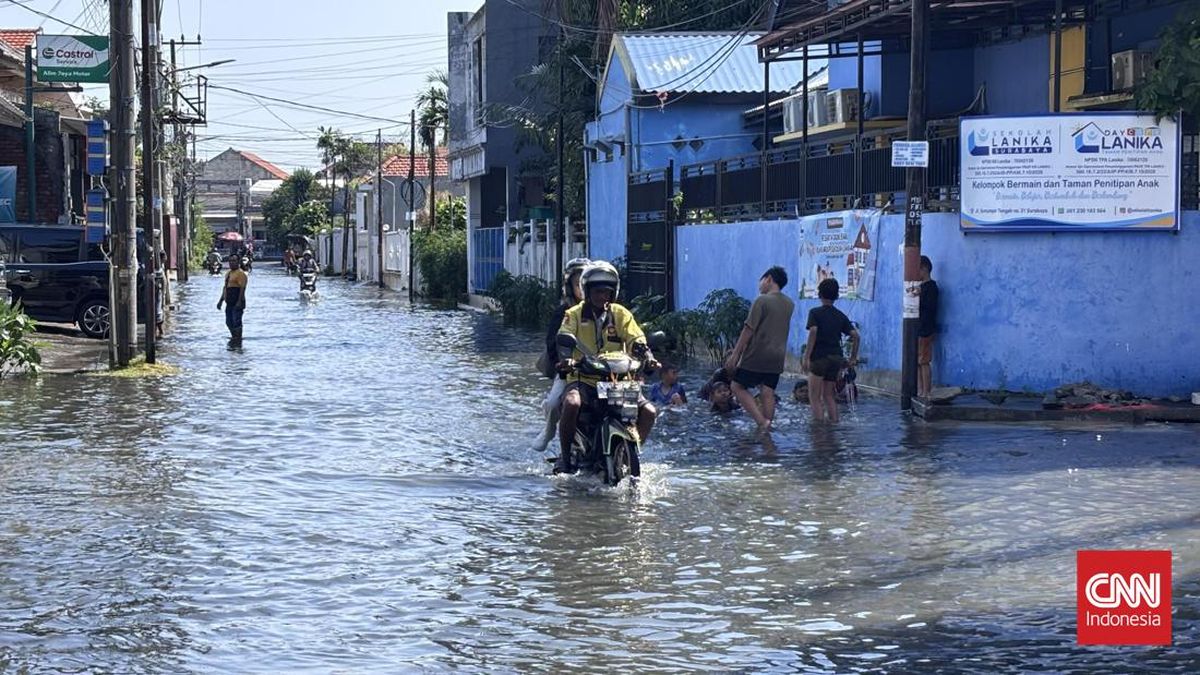
An eyewitness account from CNNIndonesia.com reporters at one of the still-flooded areas, Nginden Intan Timur, described water levels reaching 30-50 centimeters. This depth significantly disrupted daily activities for residents, making pedestrian and vehicular movement difficult. Despite the inconvenience, some children were observed playfully wading and swimming in the floodwaters, a common sight in Indonesian communities during floods, though it carries inherent health risks. "It wasn’t this high this morning," remarked Wisnu Priyo (32), a local resident, indicating the fluctuating nature of the water levels throughout the day.
Beyond Floods: Collateral Damage from Extreme Weather
The extreme weather conditions were not limited to heavy rainfall and flooding; they also caused significant structural damage and environmental hazards across Surabaya. In addition to the widespread inundation, the strong winds accompanying the rain led to the felling of four large trees in various parts of the city. Linda Novanti confirmed these incidents, detailing that the tree falls occurred at Jalan Diponegoro Tegalsari, Jalan T.A.I.S. Nasution Genteng, Jalan Pagesangan Agung Baru Jambangan, and Jalan Wiguna II Gunung Anyar.
The types of trees involved varied, including tabebuia, jackfruit, sengon, and trembesi, with heights ranging from 5 to 20 meters. These substantial trees posed considerable risks to public safety and infrastructure, blocking roads and potentially damaging properties. Fortunately, a swift and coordinated response from joint teams of the BPBD and the Environmental Agency (DLH) ensured that all four fallen trees were promptly cleared. "All four fallen trees have been handled by the joint officers from BPBD and DLH," Novanti stated, underscoring the efficiency of the emergency services.
Further compounding the damage, one residential house located at Jalan Kalijudan No. 80, Mulyorejo District, suffered significant structural damage. Reports received by BPBD at 05:51 WIB on Tuesday indicated that a section of the house’s roof had collapsed. The incident affected one household comprising five individuals. Crucially, Linda Novanti confirmed that there were no casualties or injuries reported from the house collapse. The fallen roof impacted the bedroom and the front living room area. Emergency personnel quickly secured the affected area and provided immediate assistance, including essential aid, to the displaced occupants.
Official Response and Ongoing Monitoring
The response to the dual-day disaster has been a coordinated effort involving multiple municipal agencies. The BPBD of Surabaya has been at the forefront of managing the crisis, deploying teams for floodwater monitoring, debris clearance, and humanitarian aid distribution. Their role has been critical in assessing the extent of the damage, coordinating with other departments, and providing timely updates to the public. The quick mobilization to clear fallen trees and assist affected households demonstrates the city’s preparedness protocols, even in the face of an unusual weather event.
BMKG Juanda, in its capacity as the primary meteorological authority, has continued to monitor the atmospheric conditions closely. While the initial forecast indicated a continuation of rainfall in certain parts of Surabaya for several more days, the intensity was predicted to gradually decrease. This ongoing monitoring and public dissemination of forecasts are vital for allowing residents and authorities to prepare for potential further impacts and to manage recovery efforts effectively. The accuracy of these forecasts is paramount for informing disaster mitigation strategies and ensuring public safety.
Surabaya’s Vulnerability: A City at Risk
Surabaya’s geographical characteristics inherently contribute to its vulnerability to flooding. As a low-lying coastal city situated on the northeastern coast of Java, it is part of the extensive Brantas River delta system. This topography means that much of the city lies at or just above sea level, making it susceptible to both riverine and tidal flooding, exacerbated by intense rainfall. The city’s extensive network of rivers and canals, while crucial for drainage, can quickly overflow when overwhelmed by unprecedented volumes of water.
Rapid urbanization and infrastructure development, a hallmark of Surabaya’s growth as a major economic hub, also present significant challenges to effective flood management. As the city expands, natural drainage areas are often replaced by impervious surfaces like concrete and asphalt, which prevent rainwater from being absorbed into the ground. This increases surface runoff, placing immense pressure on existing drainage systems, many of which may not have been designed to cope with the intensity and volume of water experienced during such extreme weather events. The aging infrastructure in some parts of the city, coupled with the challenges of maintaining and upgrading these vast systems, further compounds the problem.
The recent unseasonal downpour in Surabaya serves as a stark reminder of the increasing unpredictability of weather patterns globally, often linked to the broader phenomena of climate change. While a single event cannot be definitively attributed to climate change, the observed trend of more frequent and intense extreme weather events, even outside typical seasons, aligns with climate projections. For a densely populated urban area like Surabaya, these events underscore the urgent need for enhanced climate resilience strategies, including investments in robust flood defenses, improved urban planning that incorporates green infrastructure, and sophisticated early warning systems.
Long-Term Implications and Resilience Building
The implications of such a significant flood event extend beyond immediate damage and disruption. Economically, prolonged flooding can halt commercial activities, disrupt supply chains, and impact small and medium-sized enterprises (SMEs) that form the backbone of the local economy. Transportation networks are paralyzed, leading to lost productivity and revenue. For residents, the economic burden includes property damage, increased repair costs, and potential loss of income due to inability to commute to work.
From a public health perspective, stagnant floodwaters create ideal breeding grounds for disease-carrying mosquitoes and can lead to the spread of waterborne diseases if sanitation systems are compromised. The psychological impact on affected communities, facing repeated disruptions and potential losses, also cannot be overlooked.
Looking ahead, Surabaya’s local government, in collaboration with national agencies, will need to prioritize investments in resilient urban infrastructure. This includes upgrading and expanding its drainage networks, maintaining and improving pumping stations, and potentially exploring nature-based solutions such as permeable pavements and urban green spaces that can absorb excess rainwater. The incident also highlights the critical importance of robust early warning systems that can effectively communicate risks to the public, allowing for timely preparedness and evacuation if necessary.
Ultimately, the unseasonal deluge in Surabaya is a complex event shaped by specific meteorological conditions, geographical vulnerabilities, and urban development challenges. It serves as a powerful call to action for enhancing urban resilience and adapting to a future where unpredictable weather patterns may become the new norm, requiring comprehensive and forward-thinking strategies to protect its citizens and sustain its growth.


