Skies of Fire: Understanding the Science and Impact Behind the Ominous Orange Haze Viral Across Borneo

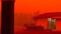
The emergence of a striking and ominous deep orange to reddish sky across multiple regions in Kalimantan has recently captured widespread public attention, spreading rapidly across various social media platforms and sparking concern among local residents. Videos and photographs uploaded by internet users depicted an eerie twilight-like atmosphere during daytime hours, prompting widespread speculation regarding the underlying causes of the atmospheric discoloration. Amid mounting public anxiety, scientific authorities have stepped forward to demystify the spectacle, attributing the surreal visual phenomenon to environmental factors rather than apocalyptic or supernatural occurrences. Professor Thomas Djamaluddin, a prominent Research Professor in Astronomy and Astrophysics at the National Research Agency (BRIN), provided a clear scientific explanation, noting that the vibrant hues are the direct result of dense smoke concentrations filling the troposphere. According to BRIN’s expert analysis, the peculiar orange and red color spectrum is generated through the physical process of light scattering, whereby suspended smoke particles in the atmosphere interact with solar radiation, altering the visual landscape across the affected territories of the island.
Meteorological and Atmospheric Mechanics: The Science of Rayleigh and Mie Scattering
To comprehend the full scope of the phenomenon observed in Kalimantan, one must examine the atmospheric optics at play when particulate matter invades the lower layers of the atmosphere. Sunlight appears white, but it is actually a composite of all the colors of the visible light spectrum, each possessing a different wavelength. Shorter wavelengths, such as blue and violet, scatter much more easily than longer wavelengths, such as red and orange, when they encounter gas molecules in a clear atmosphere—a phenomenon known as Rayleigh scattering.
However, when massive quantities of dense smoke, aerosolized particulate matter, and fine ash enter the air, a different optical process takes over, known as Mie scattering. Smoke particles are significantly larger than gas molecules and are comparable in size to the wavelengths of visible light. These particles scatter all wavelengths of light more uniformly, but as sunlight passes through a thick, persistent blanket of smoke, the shorter blue and violet wavelengths are heavily absorbed and scattered away from the observer’s line of sight long before they reach the ground. Consequently, the longer wavelengths—predominantly yellows, oranges, and deep reds—manage to penetrate the particulate barrier and reach human eyes, creating the dramatic crimson and amber skies that terrified and fascinated onlookers across the region. This atmospheric filtration effect is functionally identical to the optical physics that produce brilliant red sunsets, albeit intensified exponentially by the sheer density of the suspended pollutants.
Chronology of the Event: From Localized Observations to Viral Phenomenon
The atmospheric anomaly did not manifest overnight; rather, it developed progressively as environmental conditions deteriorated across several provinces in Kalimantan. The timeline of the event can be traced through official meteorological observations, satellite tracking data, and the surge of user-generated content on digital platforms.
The initial phase began with an escalation of land and forest fires, commonly referred to locally as karhutla (kebakaran hutan dan lahan), which typically intensify during the prolonged dry season. Meteorological agencies recorded a sharp spike in hotspot detections across remote forested and peatland areas, driven by below-average rainfall and sustained high temperatures. In the second phase, prevailing wind patterns shifted, carrying massive plumes of thick smoke northward and eastward, trapping the particulate matter over densely populated urban centers and residential zones.
By the third phase, visibility began to plummet significantly, forcing local transportation networks to issue warnings to motorists and river commuters. It was during this critical juncture that the sky underwent its dramatic chromatic transformation. Social media users in provinces such as Central Kalimantan, West Kalimantan, and South Kalimantan began broadcasting live videos and posting high-contrast images of the blood-orange horizon. The virality of these posts accelerated exponentially within a 48-hour window, transforming a localized environmental hazard into a national trending topic. By the fourth phase, mainstream media outlets integrated the social media reports with official scientific commentary, effectively bridging the gap between panicked speculation and verified meteorological facts.
Environmental Context: Peatlands, Dry Seasons, and Recurrent Hazards
The recurring appearance of smoke-choked orange skies in Kalimantan is deeply rooted in the island’s unique ecological geography and seasonal climate patterns. Kalimantan, comprising the Indonesian portion of the island of Borneo, is globally renowned for its vast tropical rainforests and extensive subterranean peatland ecosystems. Peatlands are critical carbon sinks composed of accumulated partially decayed organic matter formed over thousands of years in waterlogged environments.
However, when these landscapes are subjected to artificial drainage for agricultural expansion or face severe meteorological droughts, the peat dries out and becomes extraordinarily flammable. Unlike standard surface vegetation fires, peat fires burn underground, smoldering quietly for weeks or even months and releasing massive volumes of thick, carbon-rich particulate matter into the atmosphere. The regional dry season, frequently exacerbated by macro-climatic phenomena such as the El Niño-Southern Oscillation (ENSO), suppresses cloud formation and rainfall, creating the ideal environmental prerequisites for widespread ignitions. Consequently, every few years, the convergence of prolonged droughts, agricultural clearing practices, and vulnerable peatlands results in severe regional haze events that drastically alter the atmospheric chemistry of the region, setting the stage for striking optical anomalies like the recent orange skies.
Official Responses and Stakeholder Reactions
The viral dissemination of the orange sky imagery prompted immediate responses from various governmental bodies, environmental agencies, and public health officials. Local disaster management agencies (BPBD) across the affected provinces elevated their operational readiness, mobilizing firefighting task forces equipped with water-bombing helicopters and ground deployment units to combat active blizzards.
The Meteorology, Climatology, and Geophysical Agency (BMKG) issued regular updates regarding air quality indices (AQI) and visibility metrics. BMKG officials corroborated Professor Djamaluddin’s assertions from BRIN, emphasizing that the visual spectacle was a symptom of a much graver environmental and public health challenge. Local authorities urged communities to refrain from open burning and launched public awareness campaigns advising residents to minimize outdoor activities. Furthermore, provincial health departments distributed millions of protective face masks to mitigate the immediate inhalation risks posed by the high concentration of fine particulate matter, specifically targeting vulnerable demographics such as children, the elderly, and individuals with pre-existing respiratory conditions.
Health Implications and Socio-Economic Consequences
While the visual spectacle of an orange sky generates intense public fascination and viral internet engagement, the underlying reality carries severe socio-economic and public health implications. The same particulate matter responsible for scattering light into an eerie amber hue—specifically particulate matter measuring 2.5 micrometers or smaller (PM2.5)—poses profound risks to human physiology. Because PM2.5 particles are microscopic, they bypass the body’s natural defense mechanisms in the nose and upper respiratory tract, penetrating deep into the pulmonary alveoli and even entering the bloodstream.
Prolonged exposure to these high concentrations of atmospheric pollutants triggers acute respiratory infections (ARI), exacerbates asthma, and contributes to long-term cardiovascular complications. Medical facilities across the affected districts routinely report surges in patient admissions for breathing difficulties during severe haze episodes. Beyond human health, the socio-economic ramifications are far-reaching. Reduced horizontal visibility severely disrupts regional aviation, leading to flight delays, cancellations, and the temporary closure of domestic airports. Educational institutions are frequently forced to suspend face-to-face learning, shifting students to remote formats to protect them from toxic air. Furthermore, local commerce, outdoor labor productivity, and tourism experience measurable downturns as communities hunker down indoors awaiting favorable wind shifts or precipitation to clear the atmosphere.
Conclusion and Outlook
The viral phenomenon of the orange-tinted skies in Kalimantan serves as a vivid reminder of the fragile balance between human activity, regional ecology, and atmospheric science. What appears to casual social media observers as a mesmerizing, cinematic spectacle is, in scientific terms, a stark indicator of heavy atmospheric pollution driven by land and forest fires. Through the analytical frameworks provided by institutions like BRIN and BMKG, the mystery of the colored sky is resolved through the optics of light scattering by dense particulate matter. Ultimately, while the visual anomaly quickly fades once winds disperse the smoke or seasonal rains arrive, the underlying drivers—environmental degradation, climate variability, and peatland management—demand sustained structural attention to safeguard both the ecological integrity of Borneo and the health of its human population.
Related posts: